
EcoVessel
VINCENZO RENZO
No ratings yetUtilitiesAges 4+
Screenshots


About this app
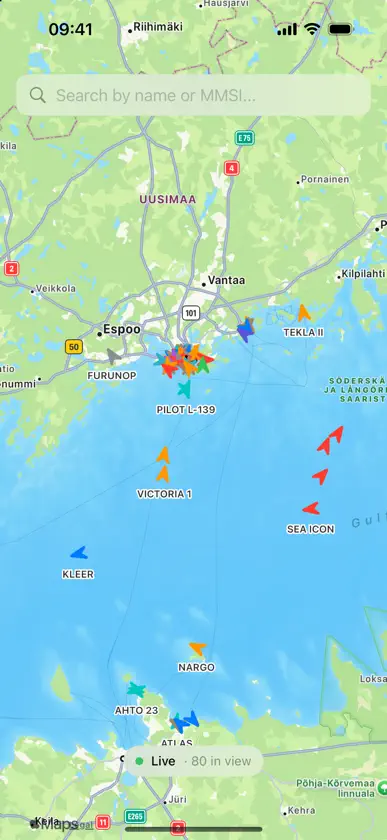
EcoVessel shows the ships around you as they really move, and estimates how much CO₂ each one is producing right now. HOW IT WORKS Every commercial ship carries an AIS transponder, a VHF radio that broadcasts its position, speed and course every few seconds, and its name, type, size and destination every few minutes. Those broadcasts are public. Volunteers, ports and coastal authorities pick them up with shore antennas and share them over the internet. EcoVessel connects to that live network: the global AISStream feed plus the official open feeds of the Norwegian Coastal Administration and Finland's Fintraffic for the Nordic and Baltic seas. GIVE IT A MOMENT Because the data arrives as it is broadcast, the map fills in progressively rather than all at once. Positions come first, so a ship may appear as an unnamed dot and gain its name, type and dimensions a few minutes later when its next identity broadcast is received. Emission totals grow the longer a ship is tracked. The status pill at the top tells you exactly what the feed is doing. COVERAGE A shore antenna hears ships out to roughly 40 to 60 nautical miles, so coverage is strongest near busy coasts, ports and straits: Northern Europe, the Mediterranean, North America and East Asia. The open ocean, and coastlines where nobody runs a receiver yet, stay empty. That is how the network works, not a fault, and the app says so when it happens. EMISSIONS YOU CAN TRUST Each ship's CO₂ rate comes from a physics-based model: hull size and type give installed power, speed sets the load, and auxiliary engines are counted on top. For about 18,000 ships the model is then calibrated against the ship's own verified annual emission report filed under the EU's Monitoring, Reporting and Verification scheme, so the figure is anchored to measured fuel, not just an estimate. Sea state and wind at the ship's position, from Open-Meteo, add a weather margin while it is underway. FOR EVERY SHIP • Live position, speed, course and heading • Name, type, flag, IMO number, length and beam • CO₂ rate, trip total, distance and time tracked • Destination resolved to a real port, with distance to go, ETA and projected CO₂ to arrival • Current waves and wind, and whether the ship is in head, beam or following seas • A photo from Wikimedia Commons where one exists, with credit Vessel types are colour-coded so cargo ships, tankers, passenger ships, fishing vessels and tugs are told apart at a glance. Tap any ship for the full picture. No account, no sign-up, no tracking of you. EcoVessel needs an internet connection and works anywhere the AIS network has ears. Data: AISStream, Norwegian Coastal Administration (NLOD), BarentsWatch, Fintraffic Digitraffic (CC BY 4.0), EMSA THETIS-MRV, UNECE UN/LOCODE, Open-Meteo (CC BY 4.0), Wikimedia Commons. Emission figures are screening-grade estimates and are not a substitute for a ship's official reporting.


