
FootPoint
Kairong Liou
No ratings yetProductivityAges 4+
Screenshots






About this app
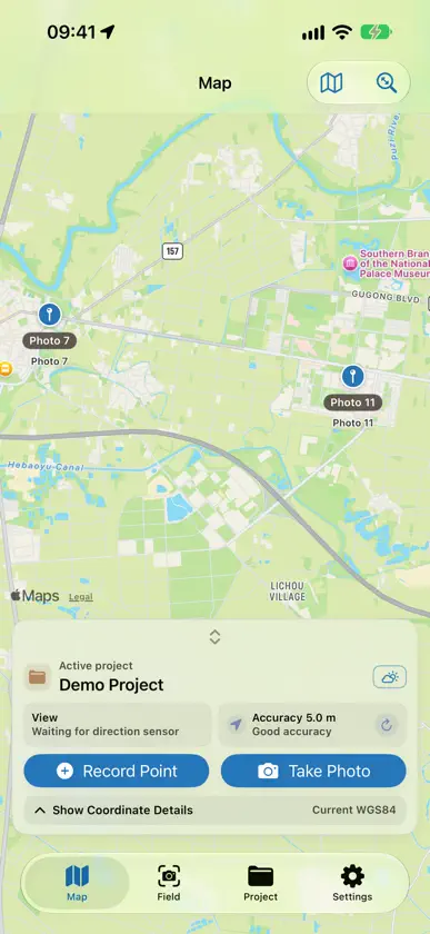
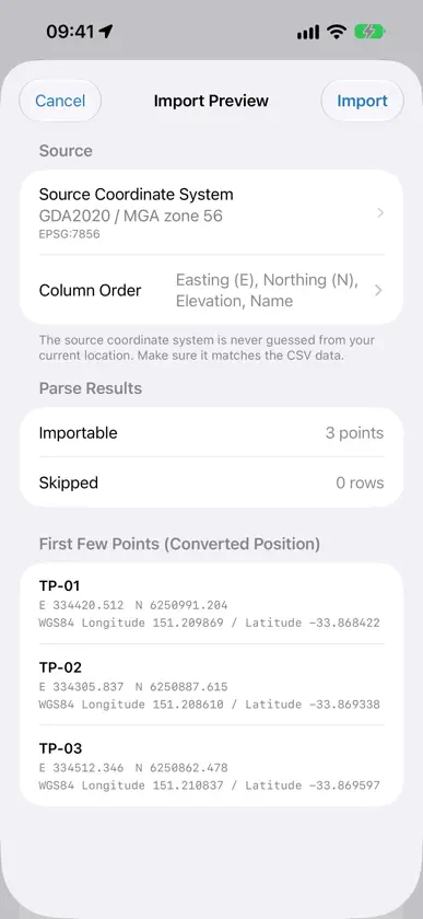
FootPoint turns field photos into location-linked records ready to review, share, and submit. When field photos pile up, it is hard to recall where they were taken, what they show, or their construction stage. FootPoint records location, camera direction, date and time, and an associated point for each photo. ■ Simple Field Workflow Create a project, add map points, or start taking photos. Set areas, trades, and construction stages, then organize records and export reports. ■ Organize by Project and Point Keep work photos separate from personal photos. Use quick-entry fields for Location, Area No., Position, Trade, Construction Stage, and Framing to avoid repetitive entry. ■ Location and Camera Direction Record where each photo was taken and camera direction, with GPS positioning accuracy for reference. ■ Coordinate Systems by Region WGS84 latitude/longitude work worldwide. Outside the regions below, only WGS84 is available. • Taiwan: TWD97/TWD67, TM2 zones 121 and 119; outlying islands automatically use zone 119. • Japan: JGD2011 Plane Rectangular Coordinate Systems I–XIX and JGD2011 latitude/longitude, covering Japan. The app recommends the nearest system by location. • Australia: GDA2020 / MGA zones 46–59 and GDA2020 latitude/longitude, covering the mainland, Christmas Island, Cocos (Keeling) Islands, and the Norfolk Island area. • New Zealand: NZTM2000, Chatham Islands TM2000, and NZGD2000 latitude/longitude, covering New Zealand and the Chatham Islands. • Great Britain: British National Grid (OSGB36) using official OSTN15 grid transformations, covering England, Wales, and Scotland—not Northern Ireland. Each point uses coordinates suited to its location, including in photo watermarks, PDF reports, and exports. The app recommends systems by current country, with manual choice in Settings › Coordinate Format. Conversion accuracy is separate from GPS accuracy. ■ Review on the Map View points, photos, and shooting directions on the map. ■ Reports and Exports Create four PDF reports: Complete, Concise, Measurement, and Site Inspection. Select contents and add a company logo or cover photo. Export CSV, KML, KMZ, GeoJSON, and TXT for CAD/GIS workflows. Photo packages support original photos, a classic date stamp, and Site info watermarks. The Full ZIP Package backs up and restores data. ■ Import Points from CSV Choose the source coordinate system and column order, including name-first layouts. Preview converted locations and skipped rows before importing. ■ Capture on iPhone, Organize on iPad Record points and photos on iPhone. Organize records, review photos, and create reports on iPad. ■ Three Languages Available in Japanese, English, and Traditional Chinese. PDF reports use the selected app language. ■ Built for Fieldwork Easy-to-tap controls designed for one-handed use. Record with limited connectivity, add locations later, and keep photos without coordinates. ■ Your Data, Your Control No account is required, and FootPoint does not automatically upload data to its own servers. Optional iCloud sync stores data in your iCloud account and syncs it between iPhone and iPad. With sync off, data stays on your device. Sharing exports or opening an external navigation app may pass location and other information to the destination. ■ 7-Day Free Trial and One-Time Pro Purchase Try all features free for 7 days. After the trial, you can still view, edit, and export existing records. Pro is required to create new projects, points, or photos. Pro is a one-time purchase, not a subscription. Site info watermarks (concise and detailed) are Pro features; original photos and the classic date stamp can still be exported after the trial. — Developed by Logua Studio. For official surveying deliverables, follow appropriate surveying procedures and verify results against established control points.
What's new
Version 1.2.2 · Oct 26, 2026
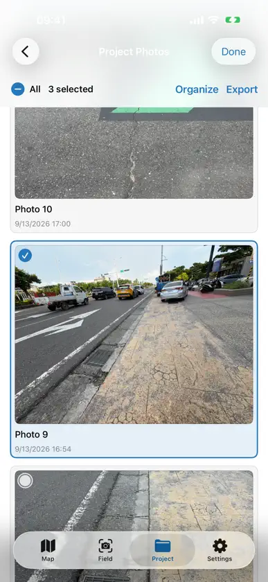
1.2.2 adds batch organizing, so you can work with many points and photos at once. ■ Batch Organizing • Tap Select in Records on iPad, or in Project Details or Project Photos on iPhone. After choosing items, tap Organize to Edit Fields (Trade, Construction Stage, Position), Add Note, Move to Another Project, Copy to Another Project, or Delete. You're always asked to confirm first. • Tapping a whole row works on the entire record. If you choose only some of its photos, only those photos are changed and the point stays. • Points without photos can be selected too. • The Export menu adds Create Report from Selection, which builds a PDF with only the photos and points you chose. • On iPhone, the selection bar in Project Photos is now at the top and includes Select All. ■ One Name for Notes • Notes on points and photos are now all called Notes, and Point Category is now Category. • A point's cover photo shares the point's notes, so you no longer see two notes fields. • The two notes switches in export settings are now one. ■ Other Improvements • "Export Data…" in the … menu is now "Export Project Data…". • On iPhone, the active project in the project list is shown with a blue outline. • iPhone Duo: the accuracy outline uses the same colors as the camera direction, and the side panel moves correctly when you unfold or fold the device. • Saving and switching projects is smoother with iCloud sync turned on. • Fixed photo numbers over two digits being cut off in Japanese, and the bracket format of directions in English.
In-app purchases
The most popular purchases on the App Store.
- ProConsumable$249.00


