
Fish Mapping
OceanBytes Holding LLC
4.2(5)NavigationAges 17+
Screenshots




About this app
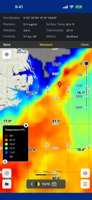
The Fish Mapping App delivers advanced, science-based fishing intelligence directly to your mobile device or desktop, helping you plan smarter and fish more efficiently. With the latest upgrades, the App now offers an enhanced experience with powerful new tools and expanded data layers designed to help anglers quickly identify fishing areas where conditions are best for bait fish to gather and where game fish are most likely to hunt. With the Fish Mapping App, anglers can view the following features on their mobile or desktop devices: • AI Hot Zones (updated daily) • Oceanographer Fish Recommendations (updated twice weekly) • Ocean data layers – Sea Temperatures, Plankton, Currents, Salinity, Thermocline (updated daily) • Altimetry & True-Color imaging (updated daily) • Bathymetry TWO WAYS TO GET FISH MAPPING • Download and then subscribe in the app for App-Only plan. Choose Annual Mobile, Annual Mobile + Desktop, or 1-Week Mobile + Desktop. • Already a SiriusXM Marine Fish Mapping satellite subscriber? Download and then activate the app with your receiver's Radio ID. The app is included with your satellite subscription. Note: SiriusXM Marine weather features are not available on the Fish Mapping App. Download the Fish Mapping App now and start using it on your Mobile or desktop devices to help plan your next fishing trip! App requires internet access. Learn more at siriusxm.com/fishmapping -------------------------- APP-ONLY PLAN OFFER DETAILS Choose either a 1-week or annual Fish Mapping App subscription plan. The 1-week plans do not renew and will end at the end of the stated term. If selecting an annual plan, service will AUTOMATICALLY RENEW each year at the then-current annual rate plus appl. tax, until you cancel. Cancel at least 24 hours before your renewal date in your Apple account (Settings → [your name] → Subscriptions) to avoid future charges. Cancellation is effective at the end of your then-current term. No refunds/credits unless permitted by Apple. App-only plans do not include satellite service. Internet access required. All fees, content, and features are subject to change. Service not available in AK or HI. SATELLITE SUBSCRIBERS Access to the app may take up to 24 hours from subscription activation to process. Satellite subscriptions require a compatible satellite-enabled device. App subscribers on a Mobile-only plan are limited to two (2) mobile devices. App subscribers on a Mobile + Desktop plan are limited to two (2) devices in any of the following combinations: 2 mobile devices, or 2 desktop devices, or 1 mobile and 1 desktop device. Changing to new devices can take up to 24 hours. Internet access is required for the Fish Mapping App. Data rates may apply. The SiriusXM Fish Mapping® App is administered by OceanBytes Holding LLC. Fish Mapping App Privacy Policy: www.siriusxm.com/fish-mapping-privacy-policy Terms of Use (SiriusXM Customer Agreement): www.siriusxm.com/customer-agreement
What's new
Version 4.0.0 · Oct 26, 2026
• Subscribe in the app: choose an annual or 1-week App-Only plan. No satellite receiver needed. • SiriusXM Fish Mapping satellite subscribers can still activate the app with their Radio ID at no additional cost. • Moon phase icon in the calendar. • Points of interest. • Land masking. • Sea Surface Temperature: min/max and contour interval settings, Celsius/Fahrenheit toggle, and raster, contour and legend display. • Plankton: min/max settings, and raster, contour and legend display. • Sea Surface Height Anomalies: min/max settings.
In-app purchases
The most popular purchases on the App Store.
- 1-Week Mobile + DesktopSubscription$24.99
- Annual MobileSubscription$199.00 / year
- Annual Mobile + DesktopSubscription$299.00 / year
More from OceanBytes Holding LLC

You might also like
 RT-NavHilton's Fishing Charts, L.L.C.
 ACR Product AppOcean Signal
 StrikeLinesStrikelines Pensacola, LLC
 1st-MateMercury Marine LLC
 Fishing Status PROJeffery Smith
 SpotOn Fishing - Fishing AppSpotOn Fishing LLC
 AI Fishing Planner: FishFathomBOATGLIDER, LLC
 Sea DepthSeadepth Charts, LLC
 Ditch: Boat NavigationExtent Devices LLC
 RhodanRhodan Marine Systems of Florida, LLC